2-D seismic surveys in sedimentary rocks

Seismic surveys can be conducted in areas with sedimentary rock formations such as those found in South Bruce. The surveys are used to generate images of subsurface layers of rock.

    Overview

    Between 2012 and 2014, the NWMO used available geoscientific information to begin the process of learning about the geology of potential siting areas containing sedimentary rock formations. These Phase 1 Desktop Studies were used to understand the regional geology and sedimentary sequence in these areas and to identify whether communities had the potential to satisfy the geoscientific site evaluation factors.

    For sedimentary rocks, the next phase of preliminary assessments includes a series of geoscientific field studies that may include observing general geological features, borehole drilling, and 2-D seismic surveys. Field studies will be conducted to advance understanding of the general geology in each community. The scope, location and timing of these studies will be developed in collaboration with communities.

    Resources:

    2-D seismic surveys

    2-D seismic surveys are conducted in areas with sedimentary rock formations such as those found in Ontario’s Bruce County. They are used to generate images of subsurface layers of rock. These studies can show the boundaries between various layers of rock and identify whether those layers are continuous or offset by faults.

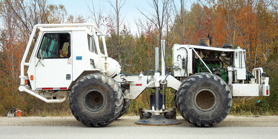
    The technique uses sound waves that travel through the ground and are reflected at boundaries between rock layers. A vibroseis truck is used to transmit vibrations into the ground. The vibrations are generated by a vibrating plate that is lowered from underneath the truck and pressed against the ground surface.


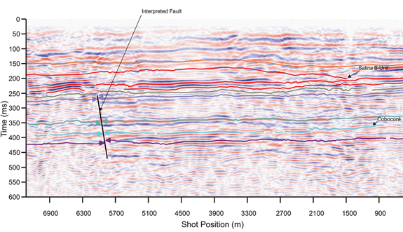
    Seismic recording devices known as geophones are placed on the ground and connected through a cable. They measure the magnitude and travel time of the vibrations reflected from underneath the surface. The output is a two-dimensional profile of the subsurface showing boundaries of different rock layers and potential locations of any subsurface structure and faults.

    Impact of vibrations

    Ground motion caused by the vibration is generally barely perceivable. The further away you are from the vibrating truck, the less you feel the vibration. Studies have shown that common household activities such as hammering a nail into a wall would cause more vibration to a house than a typical vibroseis truck operating in the area.

    Access requirements and distance from nearby structures

    The survey is conducted along a straight path called a survey line. A typical survey needs a space about five metres wide along the survey line if it is carried out in an open field. The width of this survey track can be narrower if side roads are used. Lanes of traffic usually remain open, with people holding signs to control traffic if the shoulder is narrow.

    Duration

    About three kilometres of surveys can be completed per day, depending on traffic, site constraints and weather. The number of kilometres to be surveyed will vary depending on the size of potential siting areas.

    Permitting

    No provincial permits are required. However, seismic surveying along municipal roadways and county roads requires the municipality’s permission. Surveying across private land would require the owners’ permission and agreement on access points and survey routes.

    Planning for future studies

    Geoscience experts will need several months to review the data and share findings with the community. The findings, along with those from earlier desktop studies and other field studies, will guide us in working with communities to plan any future studies.

     Additional information:

    Continue reading

    Sitecore logo

    Canada's plan

    Selecting a site
    An icon showing gears

    The site selection process

    Steps in the process